

par Banyan Gold Corp. (CVE:BYN)
Banyan Gold Confirms New Gold-Silver Discovery at Seattle Creek with 5.70 g/t Au and 544 g/t Ag over 0.5m, Nitra Project, Yukon
VANCOUVER, BC / ACCESS Newswire / August 25, 2026 / Banyan Gold Corp. (the "Company" or "Banyan") (TSXV:BYN)(OTCQB:BYAGF) is pleased to announce that the first drillhole at the Seattle Creek zone on the greenfields Nitra Project ("Nitra"), has confirmed a new high-grade gold and silver mineralized system 25 km west of the AurMac Deposit. Only the top 95 metres of the 600-metre hole have been assayed to date. Seattle Creek is located on claims 100% owned by Banyan with no underlying royalties and is the second of eleven exploration targets being drill tested in 2026 on Banyan's broader 830 sq km AurMac and Nitra land packages in the Mayo Mining District, Yukon (The discovery at the first greenfield target, Roaring Fork and the discovery at Seattle Creek was announced on July 28, 2026, with visible gold and photos of drill core at Seattle Creek.)
Highlights from Seattle Creek Zone at Nitra:
NT-26-006 - 0.91 g/t Gold and 27.01 g/t Silver over 12.1 m from 41.7 m;
including 4.04 g/t Au over 1.4 m and 3.32 g/t Au over 1.4 m; and within the 4.04 g/t Au interval, 0.5 m returned 5.70 g/t Au and 544 g/t Ag.
*Note: Only assays from the top 95 m of the 600 m NT-26-006 drillhole have been received to date; assays for the lower portion of the hole are pending.
"Initial assays from the Seattle Creek zone have returned high-grade gold and silver mineralization, adding another mineralized zone to our greenfields Nitra project," stated Tara Christie, President and CEO. "Diamond drillhole NT-26-006 intersected multiple occurrences of visible gold hosted in extensional quartz veins with associated bismuth sulphosalts and arsenopyrite. Together with the other geologic indicators, Seattle Creek has the potential to expand with follow-up drilling. The discovery of additional visible gold identified in drillhole NT-26-002, with assays pending, also supports the potential to extend the Roaring Fork Zone."
In June 2026, Banyan commenced its greenfields exploration diamond drilling program at Nitra. The program is designed to test 11 regional targets identified through new geophysical surveys, soil geochemical anomalies, placer-mining history and prospecting. More than 7,500 m of drilling is planned to use three helicopter-supported drills to minimize the initial footprint and accelerate target testing. Nitra benefits from an extensive road network established by previous placer mining activities. The objective of the program is to identify potential satellite deposits and additional expressions of Reduced Intrusion-Related Gold Systems ("RIRGs") west of AurMac, where more than 95% of Banyan's district-scale land package remains untested by drilling.
"The large, annealed shear zone, brecciated quartz veins, and multiphase sulphide mineralization, all spatially associated with high-grade gold mineralization in extensional quartz veins, are encouraging indicators of a potential larger mineralizing system at the Seattle Creek and Roaring Fork zones," stated Duncan Mackay, Vice President Exploration. "While visible gold can be an encouraging indicator, it does not always correlate with assay grade. We are encouraged that the visible gold at Seattle Creek is associated with high-grade assays and are planning follow-up drilling to test the extent and geometry of the system."
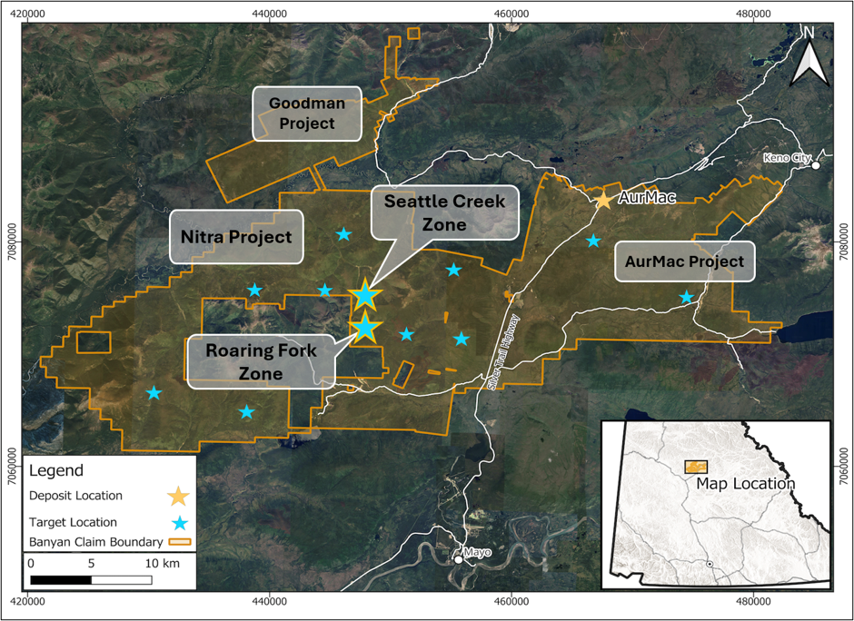
At Seattle Creek, a combination of soil geochemical anomalies (Gold, Bismuth, Arsenic) and geophysical signatures (resistive anomaly) were used to identify the target. These targeting indicators were combined with proximal placer mining in the creek drainage to locate and prioritize the targets. Mineralization at Seattle Creek is predominantly hosted in large extensional quartz vein hosting bismuth sulphosalts, arsenopyrite, pyrite, and locally sphalerite (Figure 5), and foliation sub-parallel shear veins hosting bismuth-sulphosalts, arsenopyrite, pyrite. Mineralization at Seattle Creek is spatially associated with annealed (cemented) faults with brecciated quartz vein material and wall rock entrained in a pyrite rich ground mass (Figures 7-9). Long lived/reactivated structures are strong indicators for mineralization potential with complex structural regimes and fluid pathways providing opportunities for mineralizing fluids to permeate the country rock and precipitate gold.
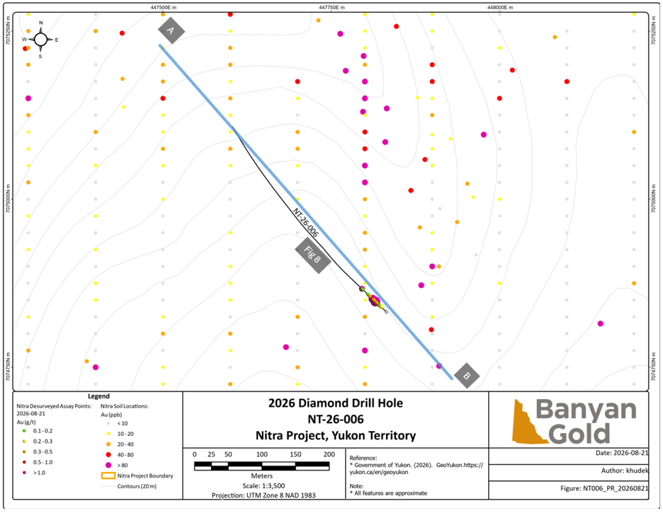
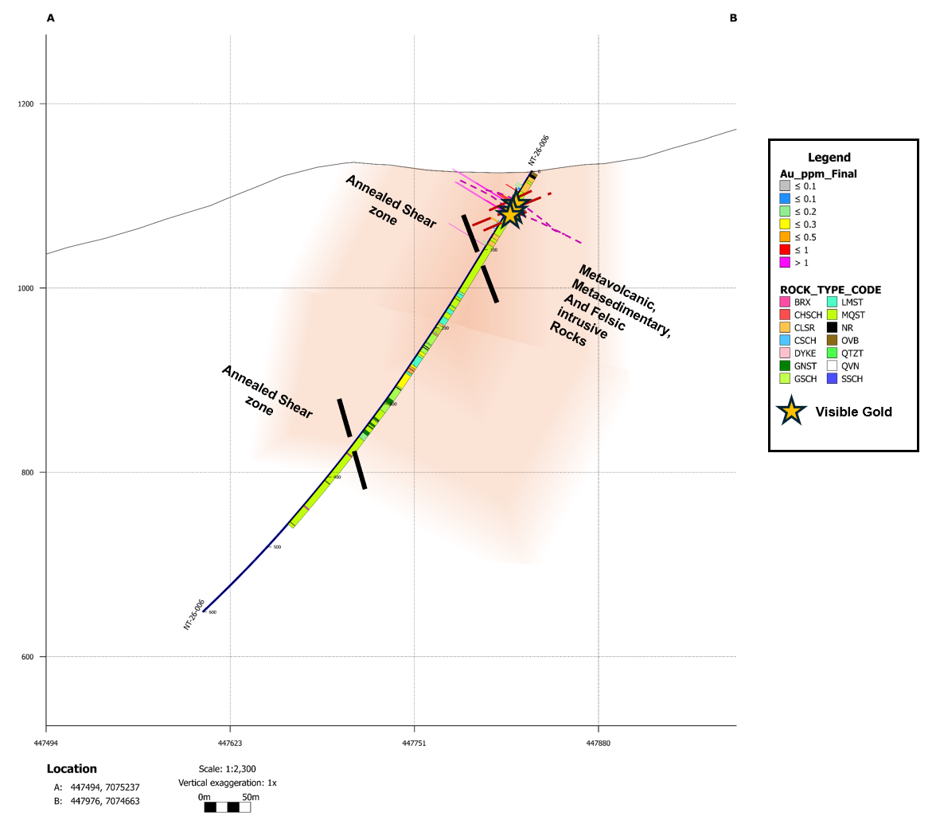
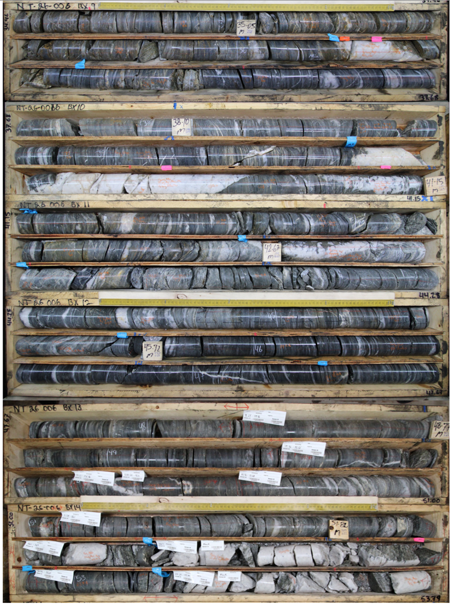
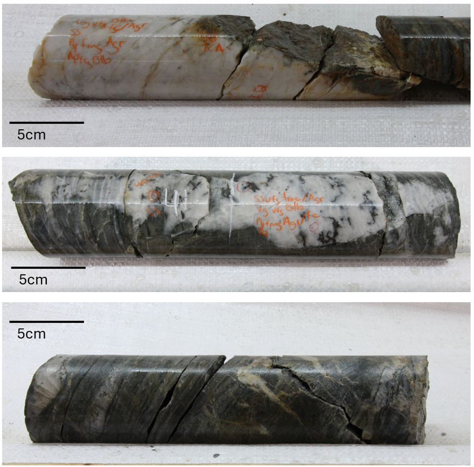
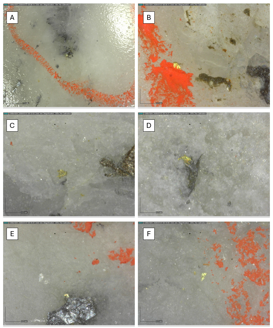
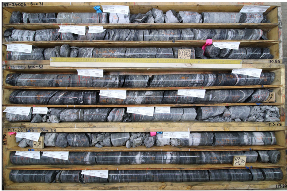

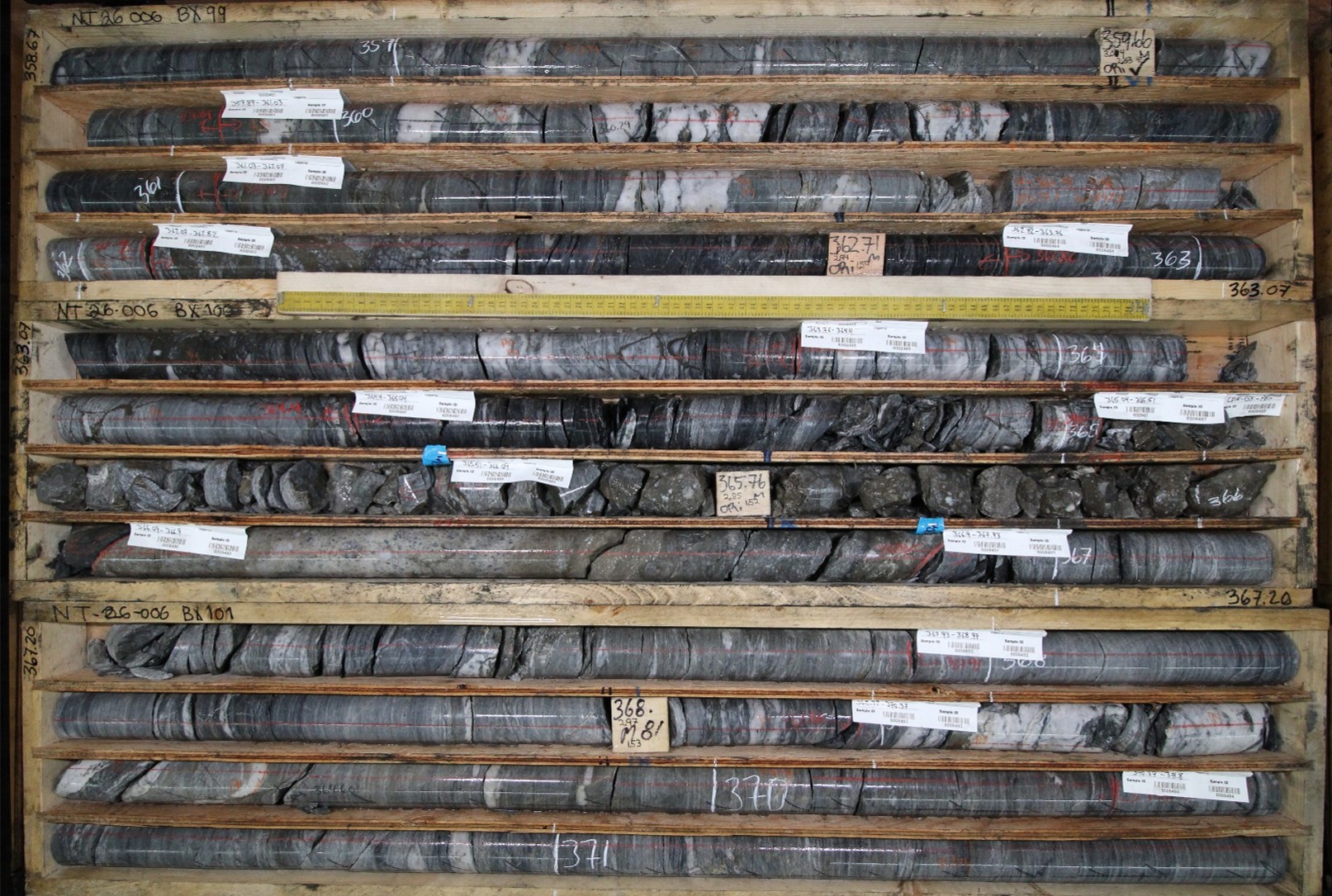
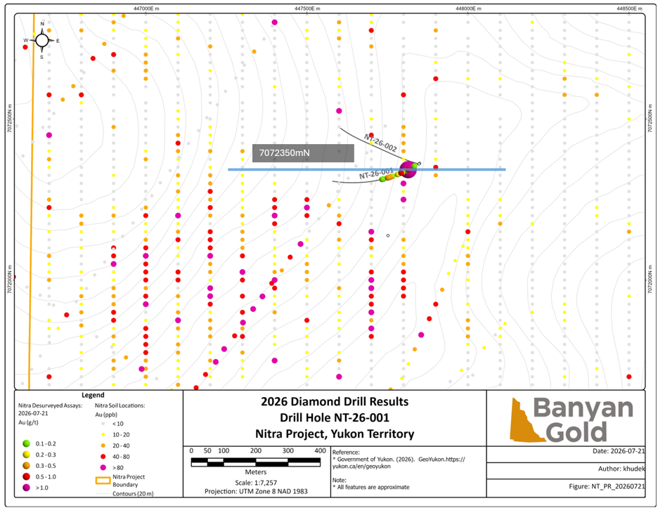
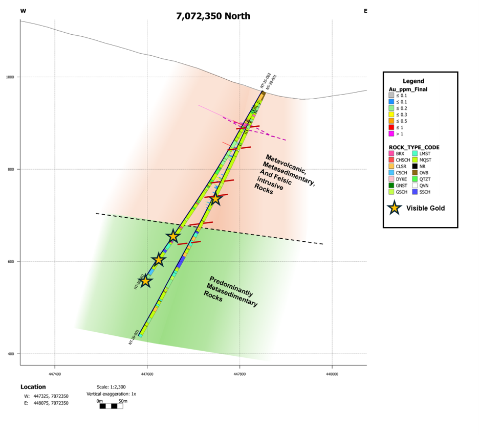
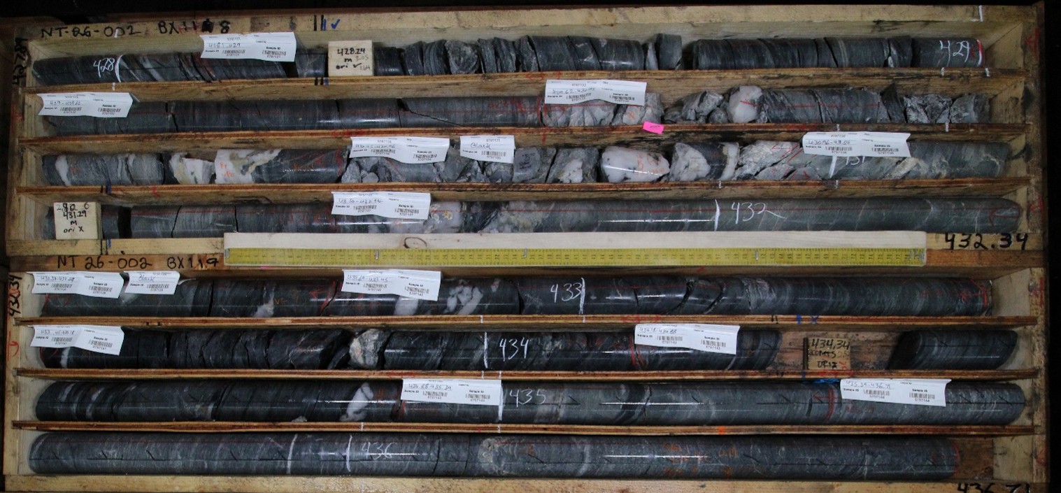
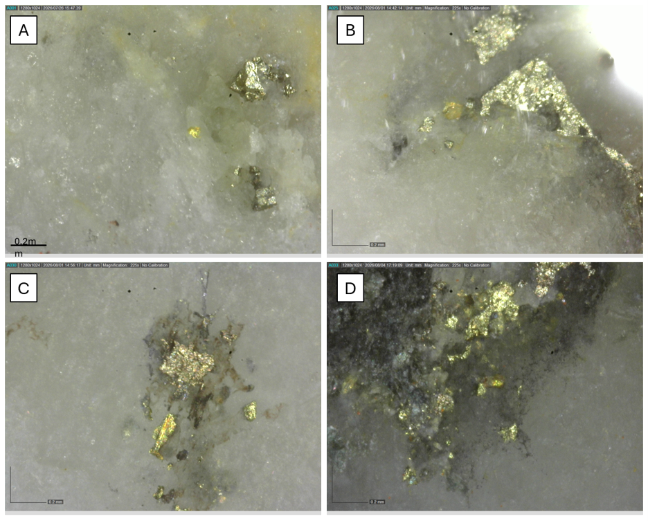
Table 1: Gold Intervals from Nitra - Seattle Creek
HOLE NUMBER | depth from | depth to | Au Interval (m) | Au Interval (g/t) |
NT-26-006 | 26.1 | 53.8 | 27.7 | 0.49 |
including | 41.7 | 53.8 | 12.1 | 0.91 |
including | 41.7 | 43.1 | 1.4 | 4.04 |
including | 42.6 | 43.1 | 0.5 | 5.7 |
and including | 52.4 | 53.8 | 1.4 | 3.32 |
and | 95.1 | 95.5 | 0.4 | 2.34 |
Note: Calculated true widths are approx. 80% of drill intervals. Further drill intersections and modelling will confirm orientation of mineralized domains.
Only assay for top 95m of the drillhole have been received to date.
Table 2: Silver Intervals from Nitra - Seattle Creek
HOLE NUMBER | depth from | depth to | Ag Interval (m) | Ag Interval (g/t) |
NT-26-006 | 41.7 | 53.8 | 12.1 | 27.01 |
including | 42.6 | 43.1 | 0.5 | 544 |
Note: Calculated true widths are approx. 80% of drill intervals. Further drill intersections and modelling will confirm orientation of mineralized domains.
Table 3: Collars for diamond drillholes in this release
Hole ID | Easting (m) | Northing (m) | Elevation (m) | Length | Azimuth | Dip |
NT-26-001 | 447850 | 7072362 | 984 | 600.5 | 240 | -60 |
NT-26-002 | 447850 | 7072362 | 984 | 495 | 285 | -60 |
NT-26-006 | 447831 | 7074832 | 1127 | 600 | 300 | -60 |
*Note: Assays for top of hole to 95m have been returned for drillhole NT-26-006; other assays pending.
Analytical Method and Quality Assurance/Quality Control Measures
The reported work was completed using industry standard procedures, including a quality assurance/quality control ("QA/QC") program consisting of the insertion of certified reference materials, field duplicates and coarse blanks into the sample stream and utilizing certified independent analytical laboratories for all assays. Additionally, historic QA/QC data and methodology on the AurMac Project were reviewed and will be summarized in the Technical Report. The Qualified Persons detected no significant QA/QC issues during review of the data.
A robust system of standards, core duplicates and coarse blanks was implemented in all Banyan's 2026 drilling programs and was monitored as chemical assay data became available. All control samples were within accuracy and precision thresholds required to meet data quality standards. These control samples amounted to approximately 10% of all samples submitted to analytical laboratories.
All diamond drill core was systematically logged and photographed by Banyan geology personnel. All core samples (HTW and NTW diameter) were split on-site at Banyan's core processing facilities. Once split, half samples were placed back in the core boxes with the other half of split samples sealed in poly bags with one part of a three-part sample tag inserted within. Samples were delivered by Banyan personnel or a dedicated expediter to either the Bureau Veritas ("BV"), Whitehorse preparatory laboratory or to AGAT Laboratories Geochemical Mining Division in Calgary ("AGAT"). Samples delivered to BV were prepared and then shipped to Bureau Veritas's Analytical laboratory in Vancouver, B.C. for pulverization and final chemical analysis. Samples delivered to AGAT were prepared, pulverized and undergo final chemical analysis in either Calgary or Thunder Bay, Ontario.
Core splits reported in this news release were analysed by either Bureau Veritas of Vancouver, B.C., or AGAT Laboratories in Calgary, Alberta. BV utilized the four-acid digestion ICP-ES 45-element MA-200 or ICP-ES/MS 59-element MA-250 analytical package with FA-450 50-gram Fire Assay with AAS finish for gold on all samples. Samples returning >10 g/t Au were reanalysed by fire assay with gravimetric finish on a 50g sample (FA-550). High-grade samples with documented visible gold were also analysed using metallic screen fire assay (FS-652). Samples returning >200 g/t Ag (MA250 or MA300) were analysed by multi-acid digestion ICP-ES MA370. If samples returned > 1,500 g/t Ag, they were analysed by fire assay with gravimetric finish on a 50g sample (FA550). If samples returned > 10,000 g/t Ag, they were analysed by fire assay 2g sample (FA501). Bureau Veritas is an accredited lab following ISO/IEC 17025:2017 SCC File Number 15895. A robust system of standards, ¼ core duplicates and blanks has been implemented in the 2026 exploration drilling program and is monitored as chemical assay data becomes available.
Core splits reported in this news release analysed by AGAT Laboratories of Calgary, Alberta or Thunder Bay, Ontario, utilized the four-acid digestion ICP-OES/ICP-MS 48-element 201-071 analytical package with 201-551 50-gram Fire Assay with AAS finish for gold on all samples. Samples returning >10 g/t Au were reanalysed by fire assay with gravimetric finish on a 50-gram sample (202-551). High-grade samples with documented visible gold are also analysed using metallic screen fire assay (202-131). Samples returning >100 g/t Ag (201-071) were analysed by multi-acid digestion ICP-OES/ICP-MS 201-470. AGAT is an accredited lab following ISO/IEC 17025:2017 SCC File Number 151266 and 151083. A robust system of standards, ¼ core duplicates and blanks has been implemented in the 2026 exploration drilling program and is monitored as chemical assay data becomes available.
Qualified Persons
Duncan Mackay, M.Sc., P.Geo., is a "Qualified Person" as defined under National Instrument 43-101, Standards of Disclosure for Mineral Projects ("NI 43-101"), and has reviewed and approved the content of this news release in respect of all disclosure other than the MRE. Mr. Mackay is Vice President Exploration for Banyan and has verified the data disclosed in this news release, including the sampling, analytical and test data underlying the information.
Upcoming Events
GCFF Conference, Vancouver, BC, September 19
Precious Metals Summit, Beaver Creek, CO, September 22-25
Corporate Presentation: September 23, 1:30 PM MDT
Denver Gold Forum Americas, Colorado Springs, CO, September 27-30
The MoneyShow Orlando, FL, October 5-7
About Banyan
Banyan's primary asset, the AurMac Project, is located in the Traditional Territory of the First Nation of Na-Cho Nyäk Dun, in Canada's Yukon Territory. The AurMac Project comprises two main deposits, the Airstrip and Powerline Deposits. Mineralization is characteristic of a Reduced Intrusion Related Gold system, hosted in auriferous cross-cutting sheeted quartz veins and replacement style mineralization hosted in skarn horizons. The current Mineral Resource Estimate ("MRE") for the AurMac Project has an effective date of May 15, 2026 and comprises an Indicated Mineral Resource of 3.639 million ounces of gold ("Au") (167.3 M tonnes at 0.68 g/t) and an Inferred Mineral Resource of 4.985 Moz of Au (267.2 M tonnes at 0.58 g/t) (See MRE Table below; as defined in the 2014 CIM Definition Standards for Mineral Resources and Mineral Reserves incorporated by reference into NI 43â101). The 303 square kilometres ("sq km") AurMac Project lies 40 kilometres from Mayo, Yukon. The AurMac Project is transected by the main Yukon highway and benefits from a 69 kVA 3-phase powerline, existing power substation and cell phone coverage.
MRE Table: Pit-constrained Indicated and Inferred Mineral Resources - AurMac Project
Cut-off Grade | Tonnes | Gold Grade | Contained Gold | |
(Au g/t) | (M Tonnes) | (g/t) | (M Oz) | |
Indicated MRE | ||||
Airstrip | 0.3 | 37.7 | 0.69 | 0.84 |
Powerline | 0.3 | 129.5 | 0.67 | 2.799 |
Combined | 0.3 | 167.3 | 0.68 | 3.639 |
Inferred MRE | ||||
Airstrip | 0.3 | 15.1 | 0.84 | 0.405 |
Powerline | 0.3 | 252.1 | 0.57 | 4.58 |
Combined | 0.3 | 267.2 | 0.58 | 4.985 |
Notes to MRE Table:
The effective date for the MRE is May 15, 2026, the technical report is available for review on SEDAR+ at www.sedarplus.ca.
The Mineral Resource Estimate was prepared by Marc Jutras, P.Eng., M.A.Sc., Principal, Ginto Consulting Inc., who is an independent Qualified Person as defined by NI 43-101.
Mineral Resources which are not Mineral Reserves do not have demonstrated economic viability. The estimate of Mineral Resources may be materially affected by environmental, permitting, legal, title, taxation, sociopolitical, marketing, changes in global gold markets or other relevant issues.
The 2014 CIM Definition Standards were followed for classification of Mineral Resources. The quantity and grade of reported Inferred Mineral Resources in this estimation are uncertain in nature and there has been insufficient exploration to define these Inferred Mineral Resources as an Indicated Mineral Resource. It is reasonably expected that the majority of Inferred Mineral Resources could be upgraded to Indicated Mineral Resources with continued exploration.
Mineral Resources are reported at a cut-off grade of 0.30 g/t gold for all deposits, using a US$/CAN$ exchange rate of 0.73 and constrained within an open pit shell optimized with the Lerchs-Grossman algorithm to constrain the Mineral Resources with the following estimated parameters: gold price of US$3,500/ounce, US$2.75/t mining cost, US$11.50/t processing cost, US$2.00/t G+A, 90% gold recoveries, and 45° pit slopes.
The number of tonnes was rounded to the nearest hundred thousand and ounces rounded to the nearest thousand. Any discrepancies in the totals are due to rounding effects.
In addition to the AurMac Project, the Company holds the Hyland Gold Project, located 70 km northeast of Watson Lake, Yukon, along the southeast end of the Tintina Gold Belt (the "Hyland Project") in the Traditional Territory of the Kaska Nations, closest to the Liard First Nation and Daylu Dena Council. The Hyland Project represents a sediment hosted, structurally controlled, intrusion-related gold deposit, within a large land package (over 125 sq km), accessible by a network of existing gravel access roads. The updated MRE comprises an Indicated Mineral Resource of 337 thousand ("K") ounces ("oz") of gold ("Au") and 2.63 million ("M") oz of silver ("Ag") (11.3 M tonnes at 0.93 g/t Au and 7.27 g/t Ag), and an Inferred Mineral Resource of 118 Koz of Au and 0.86 Moz Ag (3.9 M tonnes at 0.95 g/t Au and 6.94 g/t Ag) (as defined in the 2014 CIM Definition Standards for Mineral Resources & Mineral Reserves incorporated by reference into NI 43â101) effective September 1, 2025 and with technical report filed on Sedar on October 27, 2025.
Banyan also holds the Nitra Gold Project and Seattle-Goodman Creek Project which are grassroots exploration projects located in the Mayo Mining district, adjacent to the AurMac Gold Project. These properties lie in the northern part of the Selwyn Basin and are underlain by metaclastic rocks of the Late Proterozoic Yusezyu Formation of the Hyland Group, similar to lithologies hosting portions of the AurMac Project. Middle Cretaceous Tombstone Plutonic suite intrusions occur along the properties including the Morrison Creek and Minto Creek stocks. The properties are 100% owned by Banyan and cover over 227 sq km. The properties are accessible by road along the Silver Trail Highway, South McQuesten Road and a network of other smaller roads across the properties.
Banyan trades on the TSX-Venture Exchange under the symbol "BYN" and is quoted on the OTCQB Venture Market under the symbol "BYAGF". For more information, please visit the corporate website at www.banyangold.com or contact the Company.
ON BEHALF OF BANYAN GOLD CORPORATION
(signed) "Tara Christie"
Tara Christie
President & CEO
For more information, please contact:
Tara Christie • 778 928 0556 • tchristie@banyangold.com
Jasmine Sangria • 604 312 5610 • jsangria@banyangold.com
CAUTIONARY STATEMENT: Neither the TSX Venture Exchange, its Regulation Services Provider (as that term is defined in policies of the TSX Venture Exchange) nor OTCQB Venture Market accepts responsibility for the adequacy or accuracy of this release.
No stock exchange, securities commission or other regulatory authority has approved or disapproved the information contained herein.
FORWARD LOOKING INFORMATION: This release contains forward-looking information, which is not comprised of historical facts and is based upon the Company's current internal expectations, estimates, projections, assumptions and beliefs. Such information can generally be identified by the use of forward-looking wording such as "may", "will", "expect", "estimate", "anticipate", "intend(s)", "believe", "potential" and "continue" or the negative thereof or similar variations. Forward-looking information involves risks, uncertainties and other factors that could cause actual events, results, performance, prospects and opportunities to differ materially from those expressed or implied by such forward-looking information. Forward looking information in this news release includes, but is not limited to, the potential for resource and zone expansion; mineral recoveries and anticipated mining costs. Factors that could cause actual results to differ materially from such forward-looking information include uncertainties inherent in resource estimates, continuity and extent of mineralization, capital and operating costs varying significantly from estimates, the preliminary nature of metallurgical test results, delays in obtaining or failures to obtain required governmental, environmental or other project approvals, political risks, uncertainties relating to the availability and costs of financing needed in the future, changes in equity markets, inflation, changes in exchange rates, fluctuations in commodity prices, and the other risks involved in the mineral exploration and development industry, enhanced risks inherent to conducting business in any jurisdiction, and those risks set out in Banyan's public documents filed on SEDAR+. Although Banyan believes that the assumptions and factors used in preparing the forward-looking information in this news release are reasonable, undue reliance should not be placed on such information, which only applies as of the date of this news release, and no assurance can be given that such events will occur in the disclosed time frames or at all. Banyan disclaims any intention or obligation to update or revise any forward-looking information, whether as a result of new information, future events or otherwise, other than as required by law.
SOURCE: Banyan Gold Corp.
View the original press release on ACCESS Newswire