par Aston Bay Holdings Ltd (NASDAQ:ATBHF)
Aston Bay and American West Metals Confirm Expansion of High-Grade Copper Zones at the Storm Project, Nunavut, Canada
Intervals up to 121.2m of continuous visual copper mineralization intersected
HIGHLIGHTS
The excellent productivity for the 2024 summer drilling program continues with more than 8,300 metres ("m") now completed in 66 reverse circulation ("RC") and diamond drill holes
Visual results have been received for a further 22 drill holes, with the first assays for the summer program due within the next 2 weeks
Thunder Prospect - 2023 discovery hole 48.8m @ 3% copper ("Cu") from 32.4m:
Thick zones of visual copper mineralization have been intersected in all nine step-out drill holes at the Thunder Prospect, extending the known strike of the Thunder mineralization to over 300m and highlighting the potential for resource definition
Drill hole SR24-042 has intersected a continuous 73.2m thick zone of visual copper sulfide mineralization from 45.7m downhole including multiple zones of semi-massive sulfides
Drill hole SR24-034 has intersected a continuous 121.2m interval of visual copper sulfide mineralization from 18.3m downhole
The high-grade copper zone at Thunder remains open along strike and at depth, where drilling has only tested to approximately 100m vertical depth
Cyclone Prospect
Thick intervals of visual copper sulfides intersected in multiple drill holes, including several outside of the known zone of mineralization supporting the potential for growth and delineation of a future resource
Drill holes SR24-031 and SR-055 were drilled to the north-east of the Cyclone Prospect and have successfully expanded the strike of mineralization with intersections of 53.4m (combined total) and 80.7m (continuous)of visual copper mineralization respectively
Drill holes SR24-045 and SR24-049 have intersected thick intervals of visual semi-massive sulfides within the southern and western part of the mineralized zone
Visual estimates of mineral abundance should never be considered a proxy or substitute for laboratory analyses where concentrations or grades are the factor of principal economic interest. Laboratory assays are required to determine the presence and grade of any contained mineralization within the reported visual intersections of copper sulfides. Portable XRF is used as an aid in the determination of mineral type and abundance during the geological logging process.
TORONTO, ON / ACCESSWIRE / July 24, 2024 / Aston Bay Holdings Ltd. (TSXV:BAY)(OTCQB:ATBHF) ("Aston Bay" or the "Company") is pleased to present an update on drilling and exploration activities currently underway at the Storm Copper Project ("Storm" or the "Project") on Somerset Island, Nunavut. The program is being conducted by American West Metals Limited ("American West"), who is the operator of the Project. Aston Bay and American West have formed a 20/80 unincorporated joint venture in respect of the Storm Project property, with Aston Bay maintaining a free carried interest until a decision to mine upon completion of a bankable feasibility study.
Thomas Ullrich, Chief Executive Officer of Aston Bay, commented :
"The impressive visual results continue to come in from the drilling at Storm, highlighting the significant potential for growth and delineation of a potential future resource at the project as well as additional discoveries.
"Equally impressive are the efforts of the entire crew of drillers, geologists, geophysicists, pilots and camp support staff - we thank them for delivering results and credit them all for the success of the ongoing program."
OVERVIEW: DRILL PROGRAM ON TARGET TO EXCEED 20,000 METRES
A total of 60 RC drill holes (for approximately 7,660m) have now been completed during the 2024 drilling program. The diamond drill rig has completed 6 drill holes (for approximately 677m).
The latest drilling has been completed at the Cyclone, Chinook, Thunder, and Lightning Ridge high-grade copper prospects, and on various exploration targets within Storm. The visual results from 22 of these drill holes have been received. The mineralogy and presence of copper have been confirmed with portable XRF analysis.
The 2024 drill program is continuing with two RC and one diamond drill rig. The excellent production of the drilling achieved to date puts the program on track to complete the planned 20,000m of drilling.
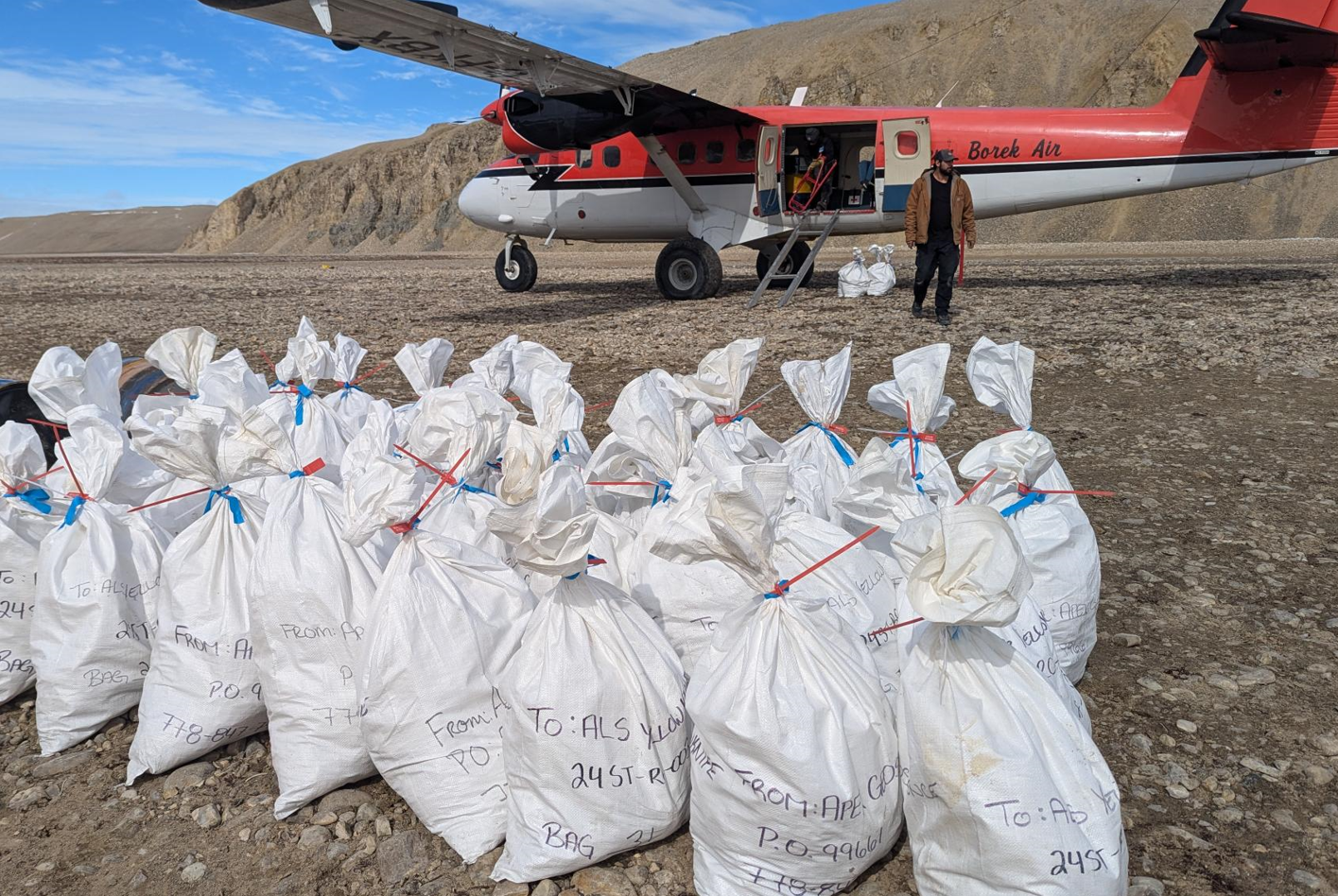
Figure 1: Reverse Circulation (RC) drill samples at the Storm Project, Nunavut, being loaded for their journey to the laboratory in Yellowknife for processing.
THUNDER COPPER PROSPECT: MINERALIZATION EXTENDED OVER 300M, OPEN IN ALL DIRECTIONS
The Thunder Prospect is located to the west of the Chinook and Lightning Ridge copper prospects. The high-grade copper zone was discovered with exploration drilling during 2023 in which drill hole ST23-03 intersected 48.8m @ 3% Cu from 32m downhole.
The discovery drill hole at Thunder was designed to test a strong EM anomaly in the vicinity of historical drilling which had intersected thin zones of high-grade copper sulfides (ST00-66 intersected 7.6M @ 1.6% Cu from 55.5m downhole, including 1.1m @ 4.8% Cu from 58.3m downhole).
The Thunder prospect is located within the extensive southern graben fault system, which hosts all known copper deposits in the southern area of Storm. The proximity of Thunder to a major fault jog and the high volume of semi-massive sulfide breccia mineralization is strongly suggestive that the copper is fault-related and steeply dipping, as seen at the nearby Chinook and Corona prospects.
The initial drilling during 2024 at Thunder has included nine widely spaced drill holes designed to test the strike extent and potential geometry of the high-grade mineralization intersected during 2023 (Figure 2 & 3).
The visual results have now been received and confirm that all drills holes have intersected visual copper sulfides, including thick intervals of very strong visual copper sulfides within the interpreted main zone of mineralization The known strike extent of the Thunder copper zone is now interpreted to be over 300m, and it remains open along strike and at depth.
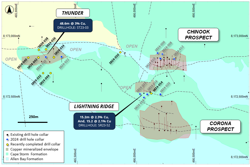
Figure 2: Plan view of the Chinook, Corona, Thunder, and Lightning Ridge areas showing the interpreted footprints of the near-surface copper mineralization (defined by drilling, MLEM and VTEM) and drilling overlaying regional geology.
THUNDER MAIN COPPER ZONE DRILL HOLE DETAILS
RC drill holes SR24-022, -030, -034, -040, and -042 were drilled along the interpreted east-west strike of the Thunder mineralized zone (Figure 2).
Drill holes SR24-030, -034, and -042 have intersected thick visual copper sulfide mineralization (approximately 58.5m, 121.9m, and 73.2m respectively). The mineralization within these drill holes is dominantly chalcocite and particularly strong in the vicinity and to the west of discovery drill hole ST23-03.
Drill hole SR24-040 is the westernmost drill hole completed to date at the Thunder Prospect. The drill hole intersected 36.6m of visual chalcocite mineralization from approximately 47.2m downhole, which contains a zone of over 5% visual sulfide at approximately 70.1m downhole. The wide interval and strong nature of the mineralization within SR24-040 suggest that the copper mineralization will likely extend further to the west.
Drill hole SR24-022 was drilled approximately 130m to the east of the main zone and intersected two intervals of minor chalcocite, chalcopyrite, and pyrite mineralization. The drill hole was drilled oriented to the south and missed the main zone of mineralization. The chalcopyrite-pyrite mineral assemblage intersected in the lower interval is typical of the margins of sediment-hosted copper systems. Further drilling is planned to determine the extent and location of the Thunder mineralization in this area.
Mineralization key: cc = chalcocite, cp = chalcopyrite, br = bornite, py = pyrite, Cu = native copper, ct = cuprite, ml = malachite, sph = sphalerite, ga = galena. (5%) = visual estimation of sulfide content.
Hole ID | From (m) | To (m) | Min | Description |
SR24-022 | 0 | 33.5 | Cape Storm Formation | |
33.5 | 35.1 | Allen Bay Formation | ||
35.1 | 38.1 | cc, ma | Veins of cc with patchy py (0.2%) | |
38.1 | 62.5 | Allen Bay dolomudstones | ||
62.5 | 67.1 | py, cp | Patchy cp (0.1%) | |
67.1 | 86.9 | py | Patchy py (0.1%) | |
86.9 | 140.2 | Allen Bay dolomudstone | ||
SR24-030 | 0 | 24.38 | Cape Storm Formation | |
24.4 | 35.1 | py | py veins (up to 0.5%) | |
35.1 | 74.7 | cc, bn, py, cp, cu | Vein with up to 5% cc, up to 1% bn, 0.5% cp, patchy py (0.2%) | |
74.7 | 77.7 | Allen Bay Fm. Dolomudstone | ||
77.7 | 115.8 | bn, cc, cp, py | Veins up to 0.5% bn, 0.1% cp, up to 1.5% cc and 0.2% py | |
115.8 | 118.9 | cc | Breccia/vein cc (7.5%) | |
118.9 | 125 | cc, cp, py | 1% patchy cc and 0.1% patchy bn and cp | |
SR24-034 | 0 | 18.3 | Allen Bay Formation | |
18.3 | 68.6 | py, cp | Intermittent cp and py (0.1%) | |
68.6 | 115.8 | py, cp | Mostly cp with cc veinlets (0.5%) | |
115.8 | 140.2 | py, cp | Cp mineralization decreasing with depth (0.2%) | |
SR24-040 | 0 | 47.2 | Cape Storm Formation | |
47.2 | 83.8 | cu, cc | cc veins and breccia throughout, 5% cc at 70.1m | |
83.8 | 123.4 | Allen Bay dolomudstone | ||
123.4 | 129.5 | Allen Bay dolomudstone | ||
SR24-042 | 0 | 39.6 | Cape Storm Formation | |
39.6 | 45.7 | Allen Bay Formation | ||
45.7 | 80.8 | cc | Breccia cc (3-5%) | |
80.8 | 118.9 | cc | Breccia cc (1-2%) | |
118.9 | 140.2 | Allen Bay Formation |
Table 1: Summary geological logs for drill holes SR24-022, -030, -034, -040, and -042.
Visual estimates of mineral abundance should never be considered a proxy or substitute for laboratory analyses where concentrations or grades are the factor of principal economic interest. Laboratory assays are required to determine the presence and grade of any contained mineralization within the reported visual intersections of copper sulfides. Portable XRF is used as an aid in the determination of mineral type and abundance during the geological logging process.
THUNDER EXPLORATION DRILL HOLE DETAILS
Four RC drill holes were drilled around the interpreted Thunder trend to determine the orientation of the high-grade copper mineralization.
Drill holes SR24-036 and SR24-038 were drilled to the north of the prospect, and were designed to test the potential lateral extension of the mineralization to the north. Both drill holes intersected thick intervals of visual copper sulfides (41.2m and 38.1m respectively). The dominant visual copper sulfide in both drill holes is chalcopyrite, with chalcocite also encountered in SR24-038.
Drill holes SR24-032 and SR24-044 are located approximately 150m south of the interpreted Thunder mineralized zone, and were drilled toward the north. This orientation was designed to test both the vertical and potential southern lateral extent of the mineralization. Both drill holes intersected thick intervals of visual copper sulfides (38.1m and 39.2m respectively), including very strong visual chalcocite mineralization in drill hole SR24-044 at approximately 86.9 - 90m downhole.
The visual copper sulfides within all of the Thunder drill holes are hosted in veinlets and breccias within the Allen Bay dolomudstones. However, the assemblage of copper minerals in the southern and northern Thunder drill holes (including abundant chalcopyrite and pyrite) suggests that they are potentially located on the margin of an east-west orientated and steeply dipping copper system. Diamond drilling is planned to confirm these assumptions.
Mineralization key for the tables below: cc = chalcocite, cp = chalcopyrite, br = bornite, py = pyrite, Cu = native copper, ct = cuprite, ml = malachite, sph = sphalerite, ga = galena. (5%) = visual estimation of sulfide content
Hole ID | From (m) | To (m) | Min | Description |
SR24-036 | 0 | 35.1 | Cape Storm Formation | |
35.1 | 76.2 | py, cp | Patchy cc and py (0.1%) | |
76.2 | 123.4 | Allen Bay Formation | ||
123.4 | 140.2 | Patchy py (0.1%) | ||
SR24-038 | 0 | 39.6 | Cape Storm Formation, trace ma (0.1%) | |
39.6 | 77.7 | cc, cp | Trace cc and cp (0.2%) | |
77.7 | 117.4 | Allen Bay Formation, dark brown | ||
117.4 | 140.2 | Allen Bay Formation |
Table 2: Summary geological logs for drill hole SR24-036 and SR24-038.
Visual estimates of mineral abundance should never be considered a proxy or substitute for laboratory analyses where concentrations or grades are the factor of principal economic interest. Laboratory assays are required to determine the presence and grade of any contained mineralization within the reported visual intersections of copper sulfides. Portable XRF is used as an aid in the determination of mineral type and abundance during the geological logging process.
Hole ID | From (m) | To (m) | Min | Description |
SR24-032 | 0 | 13.7 | Overburden | |
13.72 | 62.5 | Allen Bay Formation | ||
62.5 | 100.6 | cp | Cp veins (0.1%), more abundant 76.2-88.4m (1%) | |
100.6 | 199.6 | Allen Bay dolomudstone | ||
SR24-044 | 0 | 22.9 | Cape Storm Formation | |
22.9 | 67.1 | Allen Bay Formation | ||
67.1 |